Here We Snow! Michigan’s Upper Peninsula Could See About 12 Inches
A winter storm is getting ready to dump wet heavy, wet snow on Michigan's Upper Peninsula and some areas could see 12 inches or more of the white stuff through Tuesday.
There are two ways you can look at it:
- Well, it is the second half of October, or
- It's only the second half of October.
Here Are the Details:
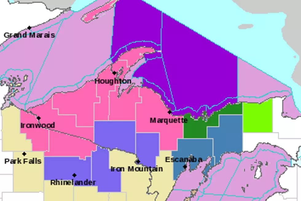
Heavy, wet snow is expected in the western half of the Upper Peninsula, with the National Weater Service issuing a Winter Storm Warning, beginning at 8 pm tonight (10/16) and staying in effect until 2 pm Monday.
The area expecting the most snow is the area stretching from the Keweenaw Peninsula - as far north as you can possibly go in Michigan - down Houghton County, west to Ironwood and east to Marquette. Folks in the Marquette area will remain under a Winter Storm Warning until about 11 am Tuesday (10/18).
But Wait, There's More
As in more snow. While 12 inches of snow in October may seem like a lot, TV 6 reports that higher elevations in Marquette and Baraga Counties could see 16 to 24 inches of snow by the end of this long-durantion snow event which is expected to last through Tuesday.
Of course, with this being October much of the ground is still warm, meaning not all of the snow that falls on the UP will stick. However, accumulations are likely which could make travel difficult.
Add in Some Wind
In addition to accumulating snow, high winds are expected throughout Upper Michigan. Wind speeds of 20 to 25 mph are expected with guests ranging from 35 to 50 mph in some areas. Even though it's still October, some Michigan residents are bracing for wind chill temps in the teens.
So wherever you are in Michigan, let's consider October a transition month. If you're in the UP, you're making a rather quick transition into winter. If you're in Southern Michigan, you're getting a preview of winter weather that will be here before you know it.
This Cozy UP Cabin is Way, Way Off the Grid
Michigan's 299 Snowplows Get the Cutest Names Ever
The 10 Best School Closing Videos of All Time
More From The Game 730 WVFN-AM


